If you are an Etsy seller like me (or sell anything at all online, for that matter), you may have thought about compiling a list of all the places to which you’ve shipped your products. “I’d love to have a world map where I can pin all the locations I’ve mailed to,” writes Edi of Memories for Life Scrapbooks in her blog post, “Friday Features – World Traveler.” In an exchange of e-mails, though, we agreed that the bigger problem could be finding a place for such a large map.
“Do a digital map that you can update,” I suggested.
“I could make it my desktop background,” said Edi.
As it turns out, there are Web sites that will create free map pinboards for you if you supply the correct information. Just visit BatchGeo, enter your addresses, and BatchGeo will automatically generate a Google map for you that you can save as an image file with your screenshot software. You can also insert the map into your blog or Web site using HTML code that BatchGeo generates and e-mails to you, free of charge. (There is a professional version available for a fee if you desire more options.)
Entering your shipping addresses doesn’t need to be a laborious process. As an Etsy seller, you can quickly download your shop data into a CSV file such as Excel. I downloaded 4 years of data in seconds, quite literally, and deleted the columns I didn’t need. Then I copied and pasted the data into the BatchGeo site. In a couple of minutes, no more, BatchGeo crunched the data and generated an interactive map. Impressive!
To create your own map pinboard, download the following sample spreadsheet from BatchGeo: Spreadsheet Template. You can modify this spreadsheet to fit your own needs, adding or subtracting columns as you wish. Make sure each column has a heading. Then:
- Copy and paste your location data into the Location Data rectangle on the BatchGeo site.
- Click on Validate & Set Options. A set of options appears that you can customize, but I accepted the default ones.
- Then, click on Make Map.
- To save this map for later viewing or editing, click on Save & Continue. A link will be e-mailed to you that you can make public if you wish.

The map that is generated is a Google map, so it is interactive. You can zoom in or out, scroll in all four compass directions, switch to a terrain or satellite view, and more. Being interactive also means that if you wish to save your map as an image file, you need to use your favorite screenshot software. (I use FireShot Pro.) When you click on “Save & Continue” in Step 4 above, you will receive an e-mail message that provides a link to your map, as well as HTML code you can insert into a blog post or Web site. This enables others to see your map.
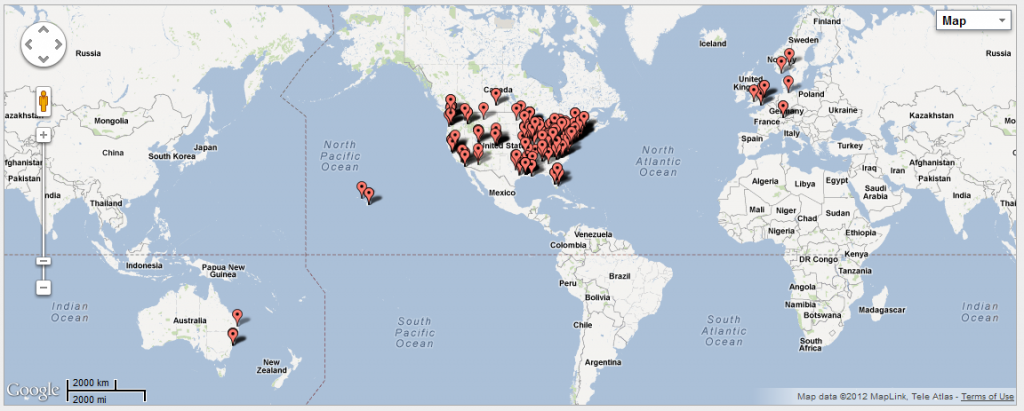
In the map below, you’ll see the locations to which I’ve shipped handmade items from JN Originals in the last 4 years. To protect the privacy of my buyers, I am showing you the screenshot I took, not the interactive map, since it is based on specific street addresses. The pushpins on the map reflect the fact that most of my buyers live in climates with well-defined seasons, especially winter. Although most of the items in JN Originals are currently cold weather products, I cannot help wondering how the map might change if I modified the type of items I make to include more seasons.
If you try this out for yourself, please let me know what you think. You can get started by clicking the BatchGeo logo below. Happy mapping!
© 2012 Judy Nolan. All rights reserved.


How fun! I love this idea and it’s great that you can update it as you go!
Awesome! Love this, Judy! Thanks for telling us how to do it quickly, too, as I probably wouldn’t even try it. Bookmarking this for a fun project.
Thank you, Judy! What a GREAT idea! And thanks for the coaching. I am definitely going to try this. My hubby and my local postal clerk are amazed by the number of international orders I’ve shipped, and my hubby has suggested I create a pin board map. But wall space was an issue. The digital solution solves that problem!
What a fun idea! I didn’t know this was possible to do digitally but I’m going to bookmark this and try it out!
SO cool!! I gotta try this when I have some time. 🙂 Thanks for sharing!
Wow, that’s pretty awesome! I love that you two conspired and then found out that a program actually already exists to do this! I still love the idea of having one on your wall at home:)
Wow, I had no idea that this was so easy! How cool that you can create this map digitally and then update it whenever you like. Thanks for sharing this concept.
What a fun idea! Thanks for sharing!